Southwestern Louisiana to undergo severe weather event
Southwestern Louisiana and other regions along the gulf coast are under a severe weather warning with the threat of Tropical Storm Barry hitting the area on Friday and continuing through the weekend. The storm has a possibility of transitioning into a Category One hurricane Saturday, but is predicted to fall back into a Tropical Storm before arriving in New Orleans.
Tulane University has closed its New Orleans and Elmwood campuses in preparation for Tropical Storm Barry tomorrow, July 11. The New Orleans campuses will reopen on Monday, July 15, and classes will resume on Tuesday, July 16. Scheduled online courses will continue to be taught while the campuses are closed, and essential personnel should consult with their supervisors during this time, Tulane University’s emergency website stated.

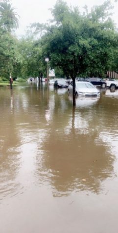
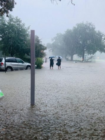
Tulane’s Uptown campus flooded July 10 in a rainstorm not associated with Tropical Storm Barry’s system. Floodwater covered Newcomb Place.
Earlier this week, New Orleans was issued a flash flood warning as streets accumulated up to four feet of rainwater. While most of the drainage began quickly after the storm disbanded, New Orleans and the area west of Baton Rouge are gearing up for an even greater weather threat this weekend. The extreme weather forecast of up to 57 mph winds and 8-16 inches of rain cumulatively has been named Tropical Storm Barry and is predicted to hit the Southerwestern Louisiana area on Friday. Louisiana Gov. John Bel Edwards has declared a state of emergency in Louisiana, and the residents of a number of parishes have been ordered to evacuate. However, while New Orleans Mayor Latoya Cantrell declared a state of emergency in the city, she is calling for residents to shelter in place rather than ordering an evacuation, abc news stated.
Tropical Storm Barry, the current 40 mph wind storm, began to move up the northern Gulf Coast of Mexico Thursday afternoon, and weather forecasters have predicted that the storm will turn into a Category One hurricane Saturday at around 7 a.m. The possible hurricane is anticipated to weaken back into a tropical storm once it reaches New Orleans, so the biggest threat to the area will be the high amounts of rainfall, rather than the strong winds. The heaviest rainfall and wind surges will occur on Saturday through Sunday, leaving potential for street flooding, tornadoes and the possibility for overtopping of levees along the Mississippi river, according to the University website and multiple news outlets.

The corner of Newcomb Place and Drill Road flooded during the downpour on July 10.
President Mike Fitts sent out an email Wednesday alerting all students of the University’s preparedness plan and to voice his concern for the safety of students on campus and residing in the New Orleans area during this time. For those students on campus who are sheltering in place, water and other provisions have been secured, and Emergency Preparedness & Response, Campus Services, Student Affairs, TUPD, Risk Management and numerous other departments are prepared for the storm to hit, Fitts wrote in the email.
“As always, our highest priority is the safety and security of the Tulane community. While multiple offices at Tulane are devoted to this purpose, the safety of the community also depends on everyone exercising caution and wisdom during this event,” Fitts wrote. “Rest assured that we are diligently monitoring the storm and its path and will provide updates to you regarding any changes to our operations or additional actions you should be taking.”
To track the storm’s path refer to https://www.cnn.com/interactive/storm-tracker/. To monitor the storm’s impact on the University’s campus, check emergency.tulane.edu or the University’s social media pages for updates. For those in New Orleans, consult https://tulane.edu/hurricane-guide-students or https://ready.nola.gov/plan/hurricane/ to prepare for the upcoming storm.
Your donation will support the student journalists of Tulane University. Your contribution will allow us to purchase equipment and cover our annual website hosting costs.


